Please help the next visitor by writing a few lines about the beach, are there toilets? Is it shallow? Is there a jetty or maybe a kiosk?
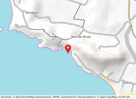
Beaches close to Pisciotto
Lido Mollarella is a sandy beach located in the province of Agrigento, with a gently sloping shoreline both above and below water level, and surrounded by typical Mediterranean vegetation. The area around the beach features a range of services, including seasonal first aid and assistance, a summer-only refreshment point, and a restaurant. Animals are allowed on the beach, as there are no signs or ordinances prohibiting their access. The competent authority responsible for the beach is the Municipality of Licata. The water quality of Lido Mollarella is classified as excellent, determined by analyzing at least four years' worth of data on contamination parameters and other relevant information. The catchment area associated with the beach is a mixed region of both agricultural and urban land, featuring single housing units, a medium-sized tourist settlement, and a stream that flows into the water near the beach. This area is known as the Salso catchment area, and is not classified as a coastal area.
Torre Di Gaffe is a sandy beach located in the province of Agrigento. It features a medium slope both underwater and above water, typical Mediterranean vegetation, and a steep terrain leading down to the beach. Access for animals is permitted, with no signage prohibiting it. The competent authority responsible for the beach is the Municipality of Licata. The quality of the bathing water is classified as excellent based on at least four years of data analysis. The area around the beach is a mixed zone, including agricultural and urbanized sections with single housing units. The catchment area is small, between Palma and Imera Meridionale, and there is a lack of data available on the collecting and treatment network for wastewater. Additionally, the purification plants do not meet the necessary standards required by the directive.
Malerba is a sandy beach located in the province of Agrigento with a medium slope of both submerged and emerged beach. This scenic spot features Mediterranean vegetation and has a steep terrain leading towards the beach. Although there are no signs prohibiting entry for animals, there are no infrastructure or services to support bathers. The competent authority for this area is Palma di Montechiaro Town Council located at Via Fiorentino. Based on the analysis of contamination parameter data over the last four years, the bathing water quality at this location is classified as excellent. However, there is a possibility of pollution due to wastewater treatment, as the collection network is not in place, and the treatment plants do not comply with the required standards of the directive. The catchment area for Malerba is a primarily agricultural region located between Palma Montechiaro and Imera Meridionale.
This is a beach located in the province of Agrigento, featuring sandy shores and a gentle slope towards the water. The area is surrounded by typical Mediterranean vegetation, and the terrain slopes gently towards the beach. There are no services or facilities available, but animals are allowed access and there are no signs prohibiting their entry. The competent authority overseeing the beach is the Municipality of Licata. The area is highly urbanised, with individual housing units and multi-storey buildings, and a large river flowing into the nearby waters. The catchment area is called the Salso river basin, coastal area number has not been specified. The quality of the bathing water has been classified as excellent, based on the analysis of the concentration of contamination parameters over the last four years.
This is a beach located in the province of Agrigento but no further information regarding its name or activity is provided.
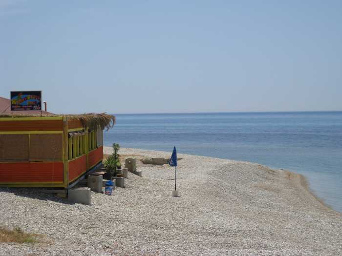
Lido Ex E.C.A. is a sandy beach located in the province of Agrigento. It boasts a gentle slope both above and below the waterline, and is surrounded by typical Mediterranean vegetation. The terrain in the surrounding area is also gently sloping. The beach has no restrictions on animals, and there is a first aid and assistance service available during the summer months. The competent authority responsible for the beach is the Municipality of Licata. The area is sparsely urbanised and primarily used for agriculture, with individual housing units scattered throughout. This is a watercourse that feeds into the waters of the beach, and this area is part of the Salso catchment area in coastal region No. The beach's water quality is categorized as excellent.
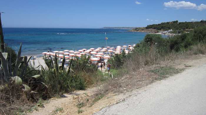
Lido Bellia is a sandy beach in the province of Agrigento, featuring a low slope both submerged and emerged, Mediterranean vegetation, and gently sloping terrain upstream towards the beach. The beach attracts a number of bathers, and offers seasonal first aid and assistance services. Animals are allowed, as there are no signs prohibiting their entry. The competent authority is the Municipality of Licata. The area is excellently classified for its bathing water quality, determined by analyzing a series of data on contamination parameters. The area of influence is mostly agricultural with scattered individual housing units, a small tourist settlement, and a watercourse flowing into the waters of the above-mentioned profile, which is part of the Salso river basin in coastal area no.
Punta Tenna is a beach located in the province of Agrigento, characterized by medium slopes of both the submerged and emerged beach and the presence of Mediterranean vegetation. The terrain surrounding the beach is steeply sloping. There are currently no infrastructure or services available, and no signs prohibit access for animals. The competent authority responsible for the beach is the town council of Palma di Montechiaro, located at Via Fiorentino. Regarding the quality of the water, it has been classified as excellent after analyzing time series data of contamination parameters for at least the past four years. However, pollution could potentially affect the bathing water quality in the catchment area, which is a predominantly agricultural area. The minor catchment area spans from Palma Montechiaro to Imera Meridionale, with the main causes of pollution being a lack of a collecting network in place and the treatment plants not complying with the required standards.
The province of Agrigento boasts a lovely beach, complete with sandy shores, a gentle slope both above and below the waterline, and abundant Mediterranean flora. The terrain slopes upwards from the beach, and there is a fair number of visitors, as well as seasonal first-aid services during the summer months. While animals are permitted on the beach, there are no official signs mentioning any restrictions. The competent authority for the beach is the Municipality of Licata, located at Piazza Progresso 09228681. Water quality at the beach is deemed excellent following the analysis of data spanning several years. The area surrounding the beach is mostly agricultural, with some individual homes scattered throughout, a large hotel complex, and a nearby watercourse leading into the same waters. This catchment area is known as the Salso River Basin, coastal area no.
This is a pebbly beach located in the province of Agrigento. The submerged and emerged beach has a low slope and is surrounded by typical Mediterranean vegetation. The terrain leading to the beach is steeply sloped. Animals are allowed access as there are no prohibition signs. The competent authority is the Town council of Palma di Montechiaro, Via Fiorentino.The location area extension and altitude are not provided as they are only applicable to lakes and rivers. The bathing water quality is classified as excellent, based on time series data analysis of concentrations of contamination parameters.The area of influence encompasses the entire catchment area associated with the bathing water. It is predominantly agricultural, with the catchment area of the Palma river being its name. The causes of pollution are due to the lack of a proper sewerage system and failing treatment plants that do not comply with the standards required by the Directive.