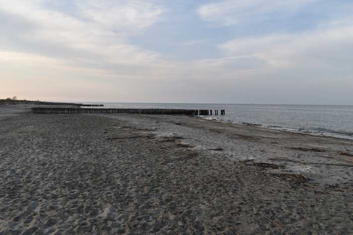
Spiaggia di Scanno cavallarinord
- Water temp(satellite):
- 13.6°C
- 2025-04-10
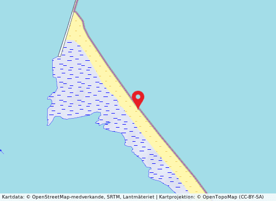
Scanno Cavallarinord is a sandy beach located in the province of Rovigo.
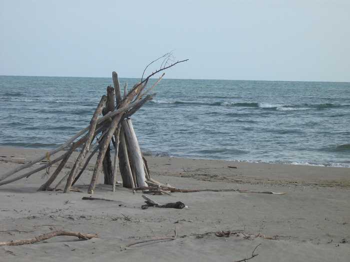
During the bathing season, there are amenities such as lifeguards, refreshment bars, and restaurants available. Access to the island is only possible by boat, and there are no activities provided. The beach spans from the mouth of the Po di Levante in the north to the mouth of the Po di Maistra in the south. Due to the absence of roads, the beach is filled with debris, mostly tree trunks. The semi-natural vegetation consists of grasses, shrubs, and distant pine forests. The beach faces SOUTH-EAST, and the bathing area is marked by a net dividing the shore and a silted-up white buoy approximately 3 km south of the Po di Levante's mouth.
Please help the next visitor by writing a few lines about the beach, are there toilets? Is it shallow? Is there a jetty or maybe a kiosk?
Beaches close to Scanno cavallarinord
Scanno Cavallarisud is a sandy beach located in the province of Rovigo, on an island. The beach provides facilities such as deckchairs and parasols, but does not offer any activities. The scanno spans from the mouth of the Po di Levante to the north to the mouth of the Po di Maistra to the south, and can only be accessed by boat as there are no roads. The beach is often covered with debris, particularly tree trunks carried by the rivers. The natural vegetation found on the beach is typical of herbaceous and shrubby flora. Facing north-east, the bathing spot is situated approximately 2.5 km south of the mouth of the Po di Levante and about 3.5 km north of the Po di Maistra. The ruins of an old fort emerging from the water can be used as a helpful reference point for visitors.
Sx Foce Po Levante is a sandy beach located in the province of Rovigo, offering first aid services, assistance for the disabled, toilets, refreshments, and sports facilities. Visitors can enjoy water sports and boat hire, and the area is clearly marked for safety. The beach faces east and is situated at the mouth of the Po di Levante, stretching from the Porto Caleri canal in the north to the mouth of the Po di Levante in the south, on the island of Albarella. The golf course and the town of Albarella are located behind the beach, with the town being sparsely populated for most of the year except during peak tourist season. The beach is surrounded by lagoons and fishing valleys, except for the seafront, and is accessible by an embankment road along the Po di Levante that connects the island to the mainland. Albarella is a tourist destination, with regulated access and limited traffic, making bicycles and electric trains the preferred mode of transportation.
Centro Albarella is a sandy beach located in the province of Rovigo. The beach boasts several amenities, including assistance and first aid services, facilities for the disabled, toilets, refreshments, and sports facilities. Visitors can enjoy engaging in water sports and renting boats, with the area being clearly marked for safety purposes. Located on the east-facing side of the island of Albarella, the beach stretches from the mouth of the Porto Caleri canal in the north to the mouth of the Po di Levante in the south. The nautical center with its swimming pools is the main attraction of the beach, while the town of Albarella behind it experiences a high influx of summer visitors but is otherwise sparsely populated throughout the year. Surrounded by lagoons and fishing villages, the beach is accessible via an embankment road along the Po di Levante that connects the island to the mainland. Albarella is an exclusive tourist destination where access is regulated, with limited traffic and mobility primarily by bicycles and electric trains.
Mare Vostrum, located in the province of Rovigo, is a beautiful beach with a sandy shoreline and a small stretch of water. The beach boasts a variety of facilities, including first aid services, disabled access, restroom facilities, refreshment options, and sports facilities. Activities such as water sports, boat rentals, and water skiing are available, and the area is signposted for safe recreational use. The beach faces west and is situated on the island of Albarella, which is densely populated during the summer but almost deserted at other times of the year. The Po delta, with its lagoons and fishing valleys, is situated across from the beach. Albarella is accessible via a well-connected embankment road, but traffic is limited to ensure the comfort of tourists visiting the island. Bicycles and electric trains contribute to transport options within the island. Overall, Albarella is a charming exclusively tourist destination.
Nord Albarella is a sandy beach located in the province of Rovigo that offers a range of services such as first aid assistance, toilet facilities, accommodations for the disabled, refreshments, and sports facilities. Visitors can engage in various activities such as water sports and boat hire, with designated areas which are clearly marked. The beach has a sloping seabed and is situated towards the northeast, stretching from the mouth of the Porto Caleri canal in the north to the Po di Levante in the south, on the Island of Albarella. It is easily accessible through Viale Gardin, with the town of Albarella located just behind it. The town is bustling during the summer and peaceful during other times of the year, surrounded by lagoons and fishing valleys. Access to the island is well-regulated with limited traffic, and visitors can travel by bicycle or electric trains along the embankment road along the Po di Levante which connects the island to the mainland.
This sandy beach is a natural and unspoiled gem on the Rosolina Mare?Caleri coastline. The beach faces east and has been left in its wild state, providing visitors with an authentic and pristine experience. This beach is the southernmost on the coastline, situated along a strip of dunes that runs between the mouth of the Adige and the Po di Levante. The area is separated from the mainland by pockets, lagoons, and sandbanks, adding to the natural beauty of the beach.The bathing spot is approximately 6 km south of the mouth of the Adige, or about 15 minutes by car. While there are no organized activities on the beach, visitors can enjoy the serenity and unspoiled natural surroundings. The absence of facilities and organized activities creates a peaceful and undisturbed environment, ideal for those looking for a quiet and natural beach experience.With its stunning natural beauty and lack of commercialization, this beach is a perfect destination for those looking to escape the hustle and bustle of more crowded and developed beach areas.
This is a natural and unspoiled sandy beach located on the Rosolina Mare-Caleri coastline. The beach faces east and offers visitors an authentic and natural beach experience. Although there are no commercial activities or facilities, visitors can appreciate the pristine and serene environment of the beach.The bathing spot is approximately 5 km south of the mouth of the Adige River, or about a 7-minute drive. With no commercialization, the beach retains its natural state, making it an ideal destination for those seeking a peaceful and untouched beach experience.Surrounded by natural dunes and vegetation, this beach provides a picturesque and tranquil setting for visitors to relax and unwind. With its stunning natural beauty and lack of commercial activities, this beach is a perfect destination for those who appreciate the simplicity and peacefulness of an unspoiled natural beach.
Sandy beach with refreshment points and four bathing establishments, two of which offer a restaurant service and one offering a bar and restaurant service. Sunbed and parasol rentals are available at these establishments. No additional activities are available.The Boccasette beach is located in the Po Delta, an area of lagoons, ponds, islands, and sand dunes that face the northeast. It is situated on a sand shoal called the Scanno del Palo, surrounded by sand dunes and protected from development, with only four bathing establishments present. The beach can only be accessed by a small wooden bridge and is located between the mouth of the Po di Maistra to the north and the northern mouth of the Barbamarco lagoon to the south. The area around the beach is a typical saltwater marsh with reeds and brackish water.
The Boccasette beach is located on the Palo Scanno, a pristine and unspoiled area with only 4 bathing establishments. Two of these establishments offer restaurant services and one offers a bar and restaurant service. Sunbed and parasol rentals are also available between points. The beach is north-east oriented and stretches from the mouth of the Po di Maistra in the north to the northern mouth of the Barbamarco lagoon in the south, within the Po Delta region, which is a rich alluvial environment comprised of lagoons, ponds, islands, and sand dunes. Access to the beach is only possible by foot, via a small wooden bridge that connects the bank to the Palo Scanno and overlooks a typical valley filled with reeds and brackish water.
Boccasette sud is a sandy beach in the province of Rovigo, Italy. The beach features refreshment points, 4 bathing establishments, two of which have a restaurant service and one with a bar/restaurant service, and sunbed and parasol hire in conjunction with the refreshment points. There are no activities available at the beach. The beach faces north-east and is located in the Po Delta, which is an alluvial environment composed of lagoons, ponds, islands and dunes. The beach stretches over a natural scanno (scanno del Palo) with sand dunes between the mouth of the Po di Maistra to the north and the northern mouth of the Barbamarco lagoon to the south. The area is unspoiled and uncontaminated with no settlements, except for the four bathing establishments, which can only be reached by foot via a small wooden bridge connecting the bank to the scanno and overlooking a typical valley of reeds and brackish water.